The original catalog entry form was a web-based document that was filled in on-line and then submitted to create a document and also to be added to the database for phylogenetic analysis. We now use a local PC-based catalog entry system using the very same set of characters. It is essential that all of the footwear included in the database are described using the same set of questions and choice of answers.
The questions where chosen so that each could be answered with only simple aids such as a hand lens and a small blunt probe. The idea was that the inspection of the sandal could be done without damaging the sandal and without the need for more expensive equipment. The questions regarding sandal construction were chosen to be rather general and applicable to a broad range of footwear, potentially representing most regions of the Earth and a variety of quite different construction methods. A different and more subtle set of questions would be needed to distinguish very similar sandals.
As we used the catalog entry form, it became apparent that the most subjective part of the entire analysis of sandal relationships was the human observer of a sandal. In order to standardize the role of the human observer, we created a guide to be used in conjunction with the form. While use of this aid does not completely eliminate all of the differences among the observers, it is a useful aid.
Determining the Region of Origin of an item of footwear
The first question to be answered on the entry form requires a determination of the region of origin of the item being characterized.
The country of origin is the country in which the footwear is assembled. If in doubt, choose “unknown origin”.
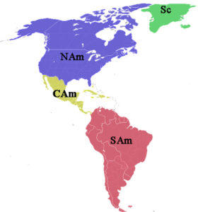
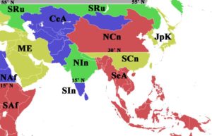
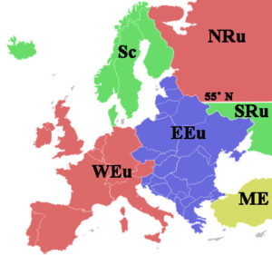
Region of origin Key
South China: SCn
North China: NCn
Japan-Korea: JpK
North America: NAm
Central Americal: CAm
South America: SAm
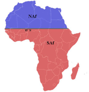
Northern Africa: NAf
Southern Africa: SAf
Middle East: ME
Western Europe: WEu
Eastern Europe: EEu
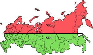
North Russia: NRu
South Russia: SRu
Scandinavia: Sc
Australia-New Zealand: AuNz
Northern India: NIn
Southern India: SIn
Southeast Asia: SeA
Central Asia: CeA
Origin Unknown: Unk
Northern China (NCn) and Southern China (SCn) are separated by latitude 30˚ N.
Northern India (NIn) and Southern India (Sin)are separated by latitude 15˚N.
Northern Russia (NRu) and Southern Russia (SRu) are separated by latitude 55˚ N.
Northern Africa (NAf) and Southern Africa (SAf) are separated by latitude 15˚N.
Explanation of divisions by latitude:
Northern and Southern Russia are separated by latitude 55˚ N
- The latitude 55 degrees North separates the Steppe from the Tundra and I think this is the logical line to use. The great grassy steppe between 45 and 55 N latitude was a prehistoric interstate highway between east Asia and Western Europe and Scandinavia. Travelers turned either north or south from the Steppe to settle and develop their cultures.
Northern and Southern India are separated by latitude 15˚ N
- India presents some interesting considerations. Latitude 15˚ N makes sense for two reasons. The main one is that migration is thought to have followed the coast around the Arabian Pen and then down the west side of India. As the migrants passed the great N/S mountain range separating modern day Pakistan and Afghanistan, they would have come to the Indus River valley at about 15˚ N Latitude. Some may have been tempted to turn N there. Also north of this parallel is all of the mountainous little provinces and countries at the edge of the Himalayas. These is a strong weaving tradition in those mountains that is likely to be different from the rest of India. However, it may be related to weaving in the Indus Valley so this will keep those areas together.
Northern and Southern China are separated by latitude 30˚ N
- For China, the logical divider is the Yangtze River. It covers 11 lines of latitude but the lower reaches are the most important for sandal culture. The30 degrees North latitude line enters just at the south edge of the Tibetan Plateau and in East China comes just below the mouth of the Yangtze which is Shanghai. In Chinese tradition, the land south of the River is called the Land of Fish and Rice. North of the River, wheat replaces rice and pork and chicken in place of fish,so there are distinguishable cultures, at least cuisines.
Northern and Southern Africa are separated by latitude 15˚ N
- Africa is challenging because climate has changed somewhat in the past 100,000 years. The 15˚ N latitude line divides the present day Sahara Desert from the grasslands in the west and in the east, it comes at the mouth of the Red Sea which has been proposed as a bridge area for early migration out of Africa and onto the Arabian Peninsula. It also leaves the entire Rift Valley in the Southern Africa part.
- The countries in Northern and Southern Africa are listed below. Some countries that are divided by the 15˚ latitude line are listed in both Northern and Southern Africa
Countries in each Region:
North America (NAm)
- Canada
- United States
Central America (CAm)
- Mexico
- Belize
- Costa Rica
- El Salvador
- Guatamala
- Honduras
- Nicaragua
- Panama
Northern Africa (NAf)
- Algeria
- Chad
- Egypt
- Eritrea
- Libya
- Mali
- Mauritania
- Moroco
- Niger
- Sudan
- Tunisia
Middle East (ME)
- Bahrain
- Cyprus
- Iran
- Iraq
- Israel
- Jordan
- Kuwait
- Lebanon
- Oman
- Qatar
- Saudi Arabia
- Syria
- Turkey
- United Arab Emirates
- Yemen
Scandinavia
- Denmark
- Finland
- Greenland
- Iceland
- Norway
- Sweden
Western Europe (WEu)
- Andora
- Austria
- Belgium
- France
- Germany
- Ireland
- Italy
- Liechtenstein
- Luxembourg
- Malta
- Monaco
- Netherlands
- Portugal
- San Marino
- Switzerland
- United Kingdom
Northern India
- Bangladesh
- Butan
- India
- Nepal
Central Asia (CeA)
- Afghanistan
- Kazakhstan
- Kyrgyzstan
- Mongolia
- Pakistan
- Tajikistana
- Turkministan
- Uzbekistan
Japan-Korea (JpK)
- Japan
- North Korea
- South Korea
Southeast Asia (SeA)
- Borneo
- Cambodia
- East Timor
- Indonesia
- Laos
- Malaysia
- Myanmar
- Papua New Guinea
- Philippines
- Singapore
- Solomon Islands
- Sumatra
- Thailand
- Vietnam
South America (SAm)
- Argentina
- Bolivia
- Brazil
- Chile
- Colombia
- Ecuador
- French Guiana
- Guyana
- Paraguay
- Peru
- Suriname
- Uruguay
- Venezuela
Southern Africa (SAf)
- Angola
- BeninBotswana
- Burkina
- Burundi
- Camaroon
- Cape Verde
- Central African Republic
- Chad
- Comoros
- Cote d’Ivire
- Democratic Republic of Congo
- Djibouti
- Erirea
- Ethiopia
- Gabon
- Gambia
- Ghana
- Guinea
- Ethiopia
- Kenya
- Lesotho
- Liberia
- Mali
- Malawi
- Madagascar
- Mauritius
- Mozambique
- Namibia
- Niger
- Nigeria
- Rawanda
- Republic of the Congo
- Säo Tomé
- Senegal
- Seychelles
- Sierra Leone
- Sudan
- Somalia
- South AFrica
- Swaziland
- Tanzania
- Togo
- Uganda
- Zambia
- Zimbabwe
Eastern Europe (EEu)
- Albania
- Armenia
- Azerbaijan
- Belarus
- Bosnia
- Bulgaria
- Croatia
- Czech Republic
- Estonia
- Georgia
- Greece
- Herzegovina
- Hungary
- Kosovo
- Latvia
- Lithuania
- Macedonia
- Moldova
- Montenegro
- Poland
- Romania
- Serbia
- Slovakia
- Slovenia
- Ukraine
